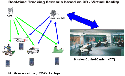
3D-Applications
Since more than 10 years we are delivering 3D-applications for panoramic views of
landscapes with added simulated objects for planning purposes, environmental impact
studies, or for reviving historic geologic eras. Such can be realized from terrestrial
stand- points or in "virtual realities" permitting a visit of the landscape from
the bird's eye view with full freedom of navigation. Combining the virtual reality
with real-time position information is the ideal platform for fleet management, VIP
tracking or SAR-tasks in difficult terrain.
Together with our technology partners we are able to offer the full spectrum of hard-
and software tools and products regarding various dedicated applications and systems
in local, regional or national scales.
In opposite to publicly internet-accessible 3D-Virtual Realities, our offer are proprietary
client-hosted solutions with an access limited to selected user groups.
Through research & technology projects, a state-of-the-art level of know-how is maintained
by Teledata GeoConsult.
3D-applications are required for e.g.
- environmental impact studies for windfarms
- cartographic / touristic use
- administrative planning purposes
- Search & Rescue (SAR)
- mission control & coordination
- Telecom network planning