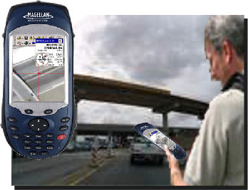


MobileMapperTMCX
MobileMapperTMCX is a highly flexible, accurate, affordable and rugged handheld GPS
receiver for universal GIS use. Compatible with Windows CE based GIS applications,
the MobileMapper CX provides real-
Together with Magellan's Mobile Mapping application, MobileMapper CX offers a turn key solution for all your GIS needs. The software is intuitive, making proficient use quick and easy with minimum training, and includes the GPS features you really need without the burden of overly complicated, rarely used functions.
Driven by the powerful office support software, MobileMapper Office, Mobilemapper CX provides clear and simple data display, editing and export capabilities. MobileMapper CX makes creating or updating maps for analysis and storage in any Geographic Information System quick and easy.
High performance features
- Real-
time sub- meter and sub- foot post- processed GPS accuracy - Open platform based on Windows CE .NET 5.0
- Multiple DGPS modes: SBAS, Beacon, NTRIP, Direct IP, and RTCM
- Support of Bluetooth and WLAN technologies
- Removable SD card memory (up to 4 GB)
Request more information or a quote for:
MobileMapper CX
MobileMapper CX with Mobile Mapping Bundle
MobileMapper CX with Mobile Mapping Bundle & Post-
MobileMapper CX with ArcPad Bundle
MobileMapper CX with ArcPad Bundle & Post-
MobileMapper CX with GPSDifferential for ArcPad Bundle
We provide also hands-